
Details about the PRACHAND – Light Combat Helicopter
PRACHAND – Light Combat Helicopter
The Prachand is India’s first indigenous multi-role combat helicopter.
Developed by Hindustan Aeronautics Limited (HAL)
- The Indian Army’s Light Combat Helicopter (LCH) Prachand recently conducted its inaugural firing during both day and night operations.
- Besides the 20mm nose gun and 70mm rockets, the LCH is equipped with a helicopter-launched anti-tank guided missile and a new air-to-air missile, which is distinct from the ‘Mistral-2’ used on the IAF LCH

Features
- Designed for: The Indian armed forces operating in deserts and mountainous areas
- Range: 700 km
- Flight ceiling: The highest among all attack helicopters in the world
- Landing and take-off altitude: 5,000 meters (16,400 ft)
- Weapons: Can carry lethal weapons and destroy targets
Significance:
The LCH has the capabilities of combat roles such as destruction of enemy air defence, counter insurgency warfare, combat search and rescue, anti-tank, and counter surface force operations.
Mercury Contamination
Mercury is a toxic pollutant that accumulates in water and sediments. It is a global pollutant that can enter the food chain and affect humans, wildlife, and fish
Tropical birds in Central and South America are exhibiting signs of mercury contamination due to artisanal and small-scale gold mining operations, according to a new study.
- Birds living within 7 km of gold mining activity were found to have mercury concentrations over four times higher than those in other areas.
Why mercury is used in Gold mining?
Mercury is used in gold mining because it forms an amalgam with gold, allowing for the extraction of gold from ore. This amalgamation process is a simple and effective way to capture fine gold particles, but it also leads to significant environmental and health concerns due to mercury pollution.
Key Findings:
- The research suggests that mercury may be playing a role in the declining biodiversity of tropical birds, which has been observed in recent decades.
Mercury contamination has been linked to neurological illness, immune diseases, and reproductive failure in both humans and birds. Birds are considered sensitive indicators of ecosystem health and are often referred to as the “canary in the gold mine” for their ability to signal environmental issues.
|
Sources of Mercury pollution: Mercury pollution can come from both natural and human-made sources. Natural sources of mercury pollution include volcanic eruptions, forest fires, and weathering of mercury-containing rocks. However, the majority of mercury pollution is caused by human activities, including:
|
What do we know about Mercury?
- About:
- Mercury is a naturally occurring element that is found in air, water and soil.
- Exposure to mercury – even small amounts – may cause serious health problems, and is a threat to the development of the child in utero and early in life.
- Mercury may have toxic effects on the nervous, digestive and immune systems, and on lungs, kidneys, skin and eyes.
- Mercury is considered by the World Health Organisation as one of the top ten chemicals or groups of chemicals of major public health concern.
- People are mainly exposed to methylmercury, (an organic compound) when they eat fish and shellfish and are more vulnerable to Minamata disease.
- Minamata Disease: A disorder caused by methylmercury poisoning that was first described in the inhabitants of Minamata Bay, Japan and resulted from their eating fish contaminated with mercury industrial waste.
- The disease is characterized by peripheral sensory loss, tremors, and both hearing and visual loss.
- Methylmercury is very different from ethylmercury. Ethylmercury is used as a preservative in some vaccines and does not pose a health risk
- Minamata Disease: A disorder caused by methylmercury poisoning that was first described in the inhabitants of Minamata Bay, Japan and resulted from their eating fish contaminated with mercury industrial waste.
Note: Kodaikanal Mercury Poisoning Episode Has Lessons for Current, Future Generations
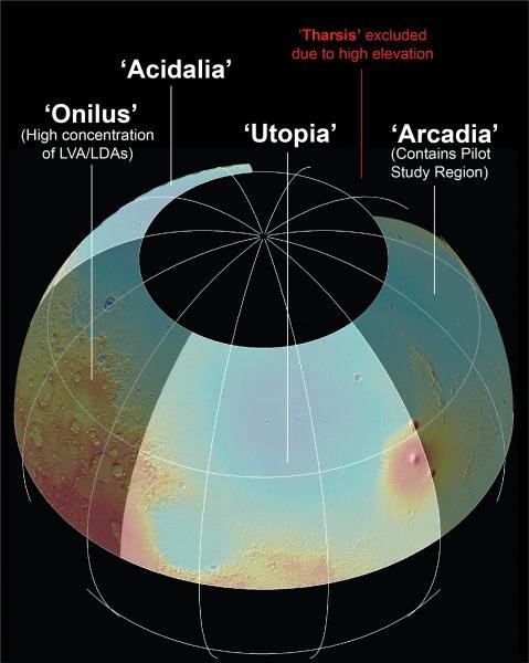
Subsurface Water Ice Mapping (SWIM)
Recently, NASA’s Subsurface Water Ice Mapping (SWIM) project released its fourth set of maps
About the Subsurface Water Ice Mapping (SWIM) project:
- It aims to locate the best places to access water ice buried under the Martian surface.
- The recently released fourth set of maps is the most detailed and accurate since the project started in 2017.
- It is led by the Planetary Science Institute in Tucson, Arizona, and managed by NASA’s Jet Propulsion Laboratory in Southern California.
- The project uses data from several NASA missions, such as the Mars Reconnaissance Orbiter (MRO), the 2001 Mars Odyssey, and the defunct Mars Global Surveyor.
- SWIM used two higher-resolution cameras on MRO.
- The Context Camera data was used to improve the maps of the Northern Hemisphere.
- For the first time, the HiRISE (High-Resolution Imaging Science Experiment) data was used to provide the most detailed view of the ice’s edge as close to the equator as possible.
- The first phase of the SWIM project, completed in 2019, focused on the northern hemisphere. The second phase, completed in 2020, includes the southern hemisphere.
Highlights of the new map
- The new map includes sightings of so-called “polygon terrain,” where the seasonal expansion and contraction of subsurface ice causes the ground to form polygonal cracks, indicating more ice hidden beneath the surface.
Future Prospects: Mars Ice Mapper Mission
- SWIM project is expected to lay the foundation for a potential Mars Ice Mapper mission, equipped with specialized radar for comprehensive exploration of near-surface ice beyond current capabilities.
- Mars Ice Mapper mission aims to enhance our understanding of Martian ice distribution and composition, contributing to future scientific exploration and potential manned missions
Potential for Life and Human Exploration:
- Presence of water ice and evidence of past liquid water suggest the potential for microbial life.
- Ongoing research and future missions aimed at assessing the planet’s habitability for human colonization and exploration